Columbia Township is best described as an “inland archipelago” – a group of nine “islands” separated by a “sea of municipalities. “Through annexations over the last two hundred years by the City of Cincinnati, Village of Fairfax, Indian Hill, Madeira, Mariemont, Norwood, and other surrounding suburban communities, The remaining township is discontinuous, the Township size diminished from being one of the largest townships in Ohio to being one of the smallest in land mass. The Islands or neighborhoods of Columbia Township are known as: Norwood Green, Ridgewood, Madison Place, Stewart Road, Ridge-Highland, Old Red Bank, Camargo Road, Plainville/Little Miami and Camp Dennison.
Columbia Township is a culturally, socio-economically and logistically diverse urban township in southeast Hamilton County, Ohio. The Township’s encompasses an area of 2.67 square miles and according the 2000 Census the population is 4,619 in the unincorporated area and 6,557 in total. The unincorporated area of the Township is approximately 2.5 square miles with 10.5 lineal miles of township roads, criss-crossed by county and state roads. Columbia Township is diverse in terms of its geographic distribution and location across the eastern portion of the Greater Cincinnati area. Columbia Township is one of twelve Townships located in Hamilton County, Ohio. The Township is adjacent to many jurisdictions including the Village of Fairfax, Mariemont, Madeira, Indian Hill, Norwood, and the City of Cincinnati.
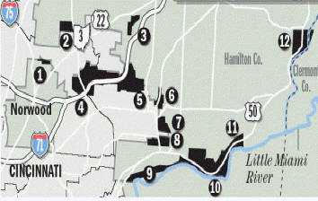
- Norwood
- Ridgewood Subdivision
- Stewart Road
- Ridge & Highland
- Old Red Bank Road
- Camargo Road
- Madison Place- North
- Madison Place – South
- Wooster Pike
- Plainville AreaWooster Pike – East
- Camp Dennison